Our Taupō office is closed Friday, 17 January and will reopen on Monday, 20 January 2025. To report air or water pollution, unsafe water activities in or on a river, lake or harbour, or make a general enquiry or information request during this time, we can be contacted 24/7 on 0800 800 401.

Close alert

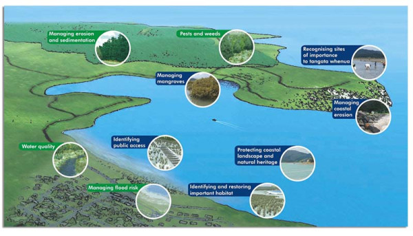
Harbour Diagram

Diagram of Whangamata harbour highlighting areas and issues WRC is involved with

Background to the plan

In 2007, Waikato Regional Council developed and asked for community feedback on the Draft Whangamata Harbour Plan and two supporting documents – the Draft Whangamata Catchment Management Plan and Whangamata Mangrove Management Options Report.

A number of issues were not resolved through the initial consultation process. As a result, a stakeholder forum was established, including representatives from:

  • Whangamata Ratepayers Association
  • Whangamata Community Board
  • Whangamata Harbour Care
  • Whangamata Marina Society
  • Hauraki Māori Trust Board
  • Te Ruunanga A Iwi O Ngāti Tamaterā
  • Te Ruunanga O Ngāti Puu Inc
  • Te Kupenga O Ngāti Hako
  • Ngāti Whanaunga Inc
  • Rayonier Forests Ltd
  • Royal Forest and Bird Society
  • Department of Conservation
  • Thames-Coromandel District Council
  • Waikato Regional Council.

In 2009 the stakeholder forum group reached agreement on the harbour and catchment plans, with the exception of the extent to which mangroves will be managed.

In July 2011, Waikato Regional Council’s river and catchment services group applied for resource consent to remove a limited number of mangroves from the harbour. The applications went through a notification, hearing and appeal process and have subsequently been granted, with a consent order and conditions issued by the Environment Court.

Whangamata Harbour Plan

The harbour plan recognises that the land and harbour are connected – what we do on the land surrounding the harbour can affect the harbour's health. The extent and importance of key concerns and risks to the harbour are identified in the plan, and the actions needed to address them are outlined.

Whangamata Catchment Management Plan

To address the issues identified in the harbour plan, the Whangamata Catchment Management Plan has prioritised specific land management, riparian enhancement and river and flood management works in the Wentworth, Waikiekie, Te Weiti and Otuwhete sub-catchments.

The primary aim of these works is to reduce the amount of soil eroding into the streams, leading to less sedimentation and infilling of the harbour. This will also help limit the places where mangroves can grow. There will be other benefits too, like more native plants, improved habitats for fish and insects and better water quality.

Related activities in the Whangamata catchment

  • Waikato Regional Council's environmental monitoring (for example, rainfall stations, coastal ecosystems, stream sediment monitoring) includes activities in the Whangamata catchment.
  • Waikato Regional Council works with other agencies through the Peninsula Project to provide river and catchment services to the Coromandel Peninsula. This project provides some works and services in the Whangamata catchment through the Whangamata catchment management plan.
  • Waikato Regional Council provides a harbourmaster and navigation safety services in the Whangamata Harbour as part of its responsibilities for managing navigation safety functions in all navigable waters within the Waikato Regional Council boundaries except Lake Taupo.
  • Waikato Regional Council supports beachcare and rivercare groups working in the Whangamata catchment.