Geothermal Systems map and information
- Environment »
- Geothermal »
- Geothermal Systems map and information
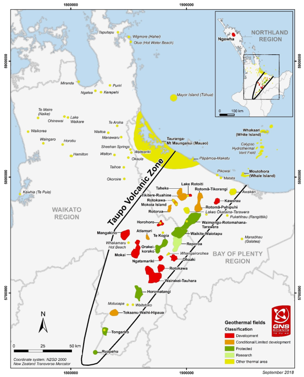
Credit to GNS and New Zealand Geothermal Association for map of the Taupō Volcanic Zone
-
Small geothermal systems in the Waikato
The smaller geothermal systems are mainly cooler, isolated sets of hot springs of tectonic origin (fed through fissures in the earth’s crust), with some on the Coromandel being remnants of ancient volcanic origin.
There are 28 known small systems in the Waikato region:
- Hamilton
- Horotiu
- Kāwhia
- Kerepehi
- Lake Waikare
- Manawarū
- Miranda
- Motuoapa
- Ngātea
- Ōhinewai
- Okauia/Opal Springs
- Okoroire
- Puriri
- Sheehan
- Taihoa
- Taputapu (Buffalo Beach)
- Te Maire
- Waikorea
- Waingaro
- Waiteariki
- Waitetoko
- Waitoa
- Walton
- Whakamaru Hot Beach
- Whangairorohea
- Wigmore (Hahei)
- Hot Water Beach
- Te Aroha.
Natural features
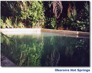
Most of the sites have hot springs or seeps, some of which form pools, depending on the nature of the surrounding ground and are in heavily modified environments.
Condition
These systems are classified as Small Geothermal Systems by Waikato Regional Council. Some of the systems have been developed and used for public swimming facilities, for example the Matamata, Te Aroha, Whitianga, Okauia and Waingaro Hot Springs.
-
About this geothermal system
Ātiamuri geothermal system contains three chloride springs in an area of farmland.
Natural features
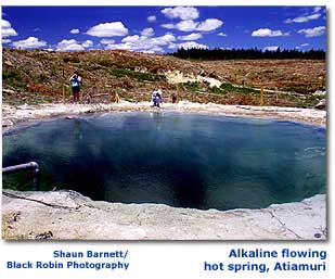
Three hot alkaline chloride springs were known, but only two are depositing sinter at present. These are known as the Whangapoa Springs.
In the arm of Lake Ātiamuri, another small hot spring was flooded when the lake was filled in the 1960s.
South of the two main hot springs is an explosion crater approximately 20 m in diameter and approximately 10 m deep. There are various other hot springs, mud pools, hydrothermal eruption craters, and extensive ancient sinter deposits scattered throughout the farmland.
The thermal fern Nephrolepsis sp. 'thermal' is present.
History
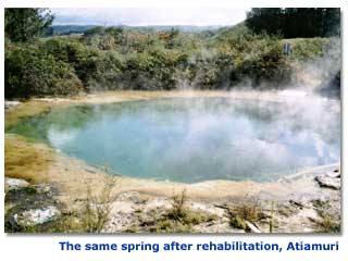
Prior to rehabilitation of the springs by the Department of Conservation in the 2000s, one of the hot springs was used by hunters for scalding the fur and feathers off game animals. Outflow from another spring was channelled to supply a concrete open air swimming pool in the 1970s. For various reasons, including the risk to bathers of contracting amoebic meningitis from the water, and to limit the vandalism that was occurring at the site, the then landowner, Carter Holt Harvey, demolished the swimming pool.
Condition
Ātiamuri is classified as a Limited Development Geothermal System by Waikato Regional Council.
Land around the system was converted from pine forest to dairy pasture in 2003. The land surrounding the Whangapoa Springs was gifted by Carter Holt Harvey to the Department of Conservation, who are now restoring the native vegetation and the springs.
-
About this geothermal system
Hydro power generation has raised river levels, flooding around 200 hot springs and 70 geysers. Thirty five active geysers and around 100 hot springs remain.
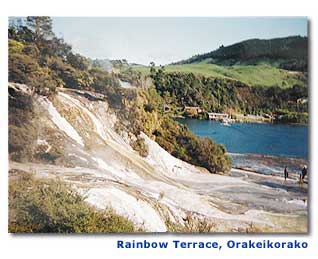
Natural features
- Most geyser activity was flooded when Lake Ohakuri (a hydro lake) was formed.
- Now 35 active geysers plus approximately 100 hot springs, plus mud pools and sinter deposits remain.
- Largest population of the rare fern Cyclosorus interruptus.
- Other rare ferns, Schizaea dichotoma, Christella sp. 'thermal' and Nephrolepsis sp. 'thermal' are also present.
History
Ōrākei Kōrako has a long history of Māori settlement and there are old photographs of wharenui (meeting houses) and people there. Some of the geothermal area at Ōrākei Kōrako remains in Māori ownership, and some has been bought back by Ngāti Tahu-Ngāti Whaoa after being taken by the Crown under the Public Works Act when the lake was created.
Condition
Ōrākei Kōrako is classified a Protected Geothermal System by Waikato Regional Council.
In 1961, Lake Ohakuri was formed for hydro power generation. This raised the Waikato River level by 18m at Ōrākei Kōrako, flooding approximately 200 alkaline hot springs and 70 geysers.
Part of Ōrākei Kōrako is managed for the Māori land owners as a tourist attraction. The system is now protected from further development.
- Most geyser activity was flooded when Lake Ohakuri (a hydro lake) was formed.
-
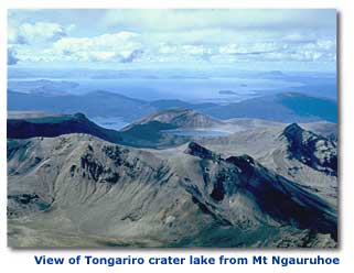
About this geothermal system
The Tongariro geothermal system contains the Ketetahi Geothermal Field which is privately owned and considered sacred by Tāngata Whenua. The public are requested to respect this by not visiting the site. Tongariro system also includes the Tongariro summit craters and the nearby Te Maari craters. In August 2012 a hydrothermal eruption occurred near the Te Maari craters. This was believed to be the first eruption since the period from 1869 to 1900 during which there were at least four occasions when eruptions occurred. There was no definite eruption in the 1900s although a questionable event was reported in the 1920s.
Natural features
The Tongariro geothermal system has:
- three to five acid geysers
- hot springs and pools, steam and gas vents, fumeroles, mud pools, sulphur deposits and a hot stream
- New Zealand's only high-altitude geothermal system apart from the recently discovered Ruapehu geothermal system
- unique high altitude geothermal vegetation and a unique insect species (midge).
Condition
Tongariro is classified as Protected by Waikato Regional Council.
Tāngata Whenua have retained ownership of the land directly around Ketetahi. Outside of the privately owned area, Tāngata Whenua have gifted the land to the people of New Zealand (Tongariro National Park) and it is legally protected.
The Ketetahi geothermal area is considered sacred by Tāngata Whenua, and the public are requested to respect this by not visiting the site.
-
About this geothermal system
Land drainage for farming has reduced sinter deposits at Waikite Geothermal Field, but hot springs, geysers and other natural features remain. The Department of Conservation is restoring the large geothermal wetland and returning farmland to its natural state.
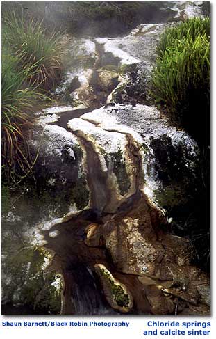
Natural features
Waikite has hot springs, geysers, warm lakes, craters and sulphur deposits.
In the early 1980s, a new spring formed and started geyser activity close to overhead high tension power lines. The HT Geyser used to erupt 5 – 8 m high many times daily during the 1980s.
Thermal ferns are present including: Nephrolepsis sp. 'thermal', Dicranopteris linearis, Christella sp. 'thermal' and Cyclosaurus interruptus.
This field may be connected to the Waiotapu and Waimangu fields.
Condition
Waikite is part of the Waikite - Waiotapu - Waimangu geothermal system, which is classified as Protected by Waikato Regional Council.
The springs are still depositing sinter, but sinter deposition has greatly reduced since the area has been developed for farming and much of the low lying ground has been drained. The Department of Conservation has now reversed the drainage and restore the natural water level.
The North Gully Springs are located below the road, so gravel and litter from passing traffic could fall into the springs. These Springs are vulnerable to damage from roadworks.
At the Waikite Scarp Swamp Springs, blackberry is smothering native plants.
The white sinter-like deposit known as travertine, which is composed of calcite rather than silica, now present around the Manuroa Spring site appears virtually identical to that shown in a photo taken in the 1890s. Here, the travertine extends for more than 1m wide around the pool edges and in thick deposits along the outflow channel.
Manuroa is believed to have the largest volume of outflow of all geothermal springs in New Zealand. Access to it has been developed by the proprietor of the nearby thermal bathing pools.
No geysers are believed to have been active in recent years, although the geyser field is difficult to monitor due to the rampant blackberry.
-
About this geothermal system
The main area of geothermal activity at Waiōtapu Geothermal Field is part of a scenic reserve and is legally protected. It is New Zealand’s most colourful thermal area.
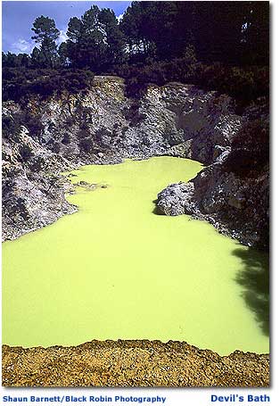
Natural features
Waiōtapu is the most colourful thermal area in New Zealand. It has five known geysers, hot springs, mud pools, fumaroles, craters, and steaming ground.
Several hot springs deposit sinters. Two of the springs are unique in New Zealand for very different reasons.
The first, Champagne Pool, is a large spring approximately 30m wide, which is actively growing two hectares of sinter terrace. The second, Hakareteke Geyser, is the only sinter-depositing geyser with acidic waters in New Zealand.
The rare thermal fern Cyclosorus interruptus is present.
This field is connected to the Waikite and Waimangu fields. The Waimangu field is mostly located in the Bay of Plenty Region.
History
In the 1890s, prisoners (from a prison located on what is now the Waiotapu School camp site) used to wash their clothes and themselves in a hot spring. They found that when soap was added to the water it made the spring geyser. The spring has since been ‘soaped’ for tourists since the 1900s and was named the Lady Knox Geyser after a notable visitor to the site.
Condition
These features are located in a scenic reserve, owned by Ngāti Tahu-Ngāti Whaoa, and are legally protected. Waiotapu is part of the Waikite - Waiotapu - Waimangu geothermal system, which is classified as Protected by Waikato Regional Council.
Waiōtapu is a popular tourist attraction. Outside of the commercial tourist area, there are several spots on Kerosene Creek (Waiōtapu Stream) where locals and tourists bathe in the warm stream water.
-
About this geothermal system
Wairakei geothermal field is part of the Wairakei-Tauhara System. Wairakei Geothermal Field has been depleted by power development and no geysers remain. Hot springs and other natural features are still present. However, the Pirorirori Lake shown below, as well as many other colourful lakes near it in the Waiora Lakes area west of the borefield, are now dry.
Contact Energy Ltd operates three geothermal power stations on the Wairakei field producing 344 MW of electricity. Contact also supplies geothermal steam to several operators for direct heat use. These include Wairakei Terraces, The Prawn Park, MB Century's offices, and Wairakei Resort Hotel.
Natural features
Natural geyser activity has been irreparably damaged. However, hot springs and pools, fumeroles, steaming ground, mud pools, craters, hot seepages, a rare mud geyser and sinter terraces are still present.
The thermal fern Christella sp. 'thermal' is present. Intact vegetation zones relate to the soil temperatures.
The Craters of the Moon geothermal area is part of the Wairakei geothermal field.
Condition
Wairakei is classified as a Development Geothermal System by Waikato Regional Council.
The Wairakei-Tauhara system has been developed for power generation and most features are irreparably damaged.
The chloride water that once fed the geysers and other chloride features including several hot streams has been diverted to the power station, causing those features to run dry. Decreased pressure in the geothermal ground water is causing more steam production, increasing the area of hot ground and the activity of steam-fed features.
Activity at the Craters of the Moon has greatly increased since the Wairakei Power Station started operating in the 1950s.
Changes in land use have also affected other natural features at Wairakei:
- Introduced weeds have colonised geothermal areas.
- Geothermal streams have been diverted.
- Rubbish has been dumped into the Pirorirori Lake and other geothermal features. Areas of steaming ground have been used for dumps, including asbestos dumps. However, much of this has since been remediated.
- Other areas of hot ground have been scraped and contoured.
- Subsidence is affecting roads, buildings and underground services in parts of Taupō town.
- Some areas have experienced spread of hot ground and increased frequency of hydrothermal eruptions.
- The Waiora Lakes, a taonga of Ngāti Rauhoto, have dried up.
-
About this geothermal system
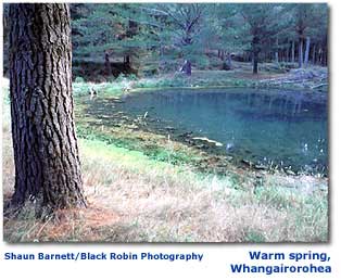
Whangairorohea Geothermal System contains several hot springs in a pine forest.
Natural features
A hot spring perched on a cliff about 5 m above a cold stream, and some springs in the bed of the Waikato River. Extensive sinter deposits indicate that this system was once much more active. In 2012 the hot spring pool was damaged by land use activities and restoration undertaken.
Condition
Whangairorohea is classified as a small geothermal system by Waikato Regional Council.
Future logging activities are likely.
-
About this geothermal system
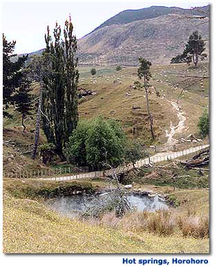
Horohoro Geothermal System has extensive old sinters and many hydrothermal eruption craters, but currently there are only two hot springs depositing small sinters in this field.
Natural features
There are presently two hot springs depositing small sinters in this field. No boiling springs or geysers have been known at this site.
Horohoro is a naturally waning geothermal system with very extensive old sinters, dried up spring basins and big explosion craters.
A commercial glasshouse operation takes heat from the system to grow flowers.
-
About this geothermal system
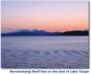
Horomatangi Reef is a pristine geothermal system on the bed of Lake Taupō.
Natural features
The Horomatangi Reef overlies an underwater geothermal system on the bed of Lake Taupō, with two distinct hydrothermal vent areas producing hot water and gases.
Hydrothermal chimneys up to 30cm tall have been built up by thermophilic micro-organisms. There are also thermophilic bacterial mats and sponges.
Condition
Horomatangi is classified as a protected Geothermal System by Waikato Regional Council.
The Horomatangi Reef is protected by its inaccessibility and is pristine.
-
About this geothermal system
The natural upwelling of hot water through the sand makes Hot Water Beach a popular spot at low tide.
Natural features
Water and gas flow up through the sand below the high tide mark.
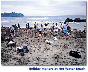
Condition
Hot Water Beach is classified as a Small Geothermal System by Waikato Regional Council.
Flow could be disrupted by ground water takes. Popular recreational spot at low tide.
Annual visitor numbers have been estimated at 700,000, making it one of the most popular geothermal attractions in the Waikato region. Find out more about the contribution of geothermal resources to the regional economy through tourism and generation.
-
About this geothermal system
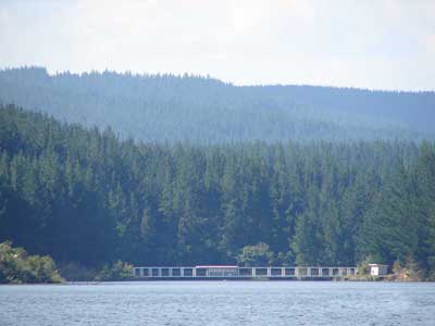
Mangakino is a large geothermal system with no remaining surface features above water level, on the western edge of the Taupō volcanic zone.
Natural features
Mangakino has no natural surface features remaining. After the creation of Lake Maraetai, the hot springs are now underwater (including one that produced sinter).
Condition
Mangakino is classified as a Development Geothermal System by Waikato Regional Council. The Mangakino system has the potential to be developed for power generation, but is currently undeveloped.
-
About this geothermal system
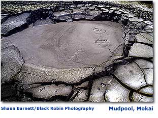
Rare geothermal plants are present at Mōkai. A 110 megawatt power station is now operating at the Mōkai Geothermal System as well as a 12 hectare geothermally heated glass house and a milk drying plant.
Natural features
- Hot springs, mud pools, steaming ground, seepages.
- Weakly sinter-depositing chloride springs.
- A rare mud geyser.
- Geothermal kanuka and the fern allies Lycopodium cernuum and Psilotum nudum are present, as well as at least 200 specimens of the rare fern Christella sp. 'thermal'.
Condition
The Mōkai field is classified as a Development Geothermal System by Waikato Regional Council.
There has been stock damage to springs and native plants in the past but now almost all areas of geothermal vegetation and features have been fenced off and native plantings established. A 55 megawatt power station commenced operation in 2000, and a 40 megawatt power station was added in 2005, followed by a 16MW upgrade in 2007.
-
About this geothermal system
The Ngā Tamariki Geothermal System is a highly dynamic area and since 1995 some springs have formed, others have dried up, and there has been a hydrothermal eruption.
Natural features
- Two large alkaline-chloride pools surrounded by bubbling acidic pools and numerous springs and pools.
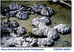
- There are six areas of sinter-depositing springs.
- One spring has dense brilliant white calcite sinter 2m wide, for 5m along its outflow.
- In late 1998, a new geyser appeared at Ngā Tamariki after a bank collapsed and blocked a natural upwelling of geothermal fluid.
- Some thermal ferns are present.
Condition
Ngā Tamariki is classified as a Development Geothermal System by Waikato Regional Council.
Currently, the site is in a good condition. However, there are unstable banks near several of the springs, which may collapse. Future logging of the nearby pine plantation could damage the sinter terraces. The Rotokawa Joint Venture, consisting of Mercury Energy and Tauhara North No. 2 Trust operate an 82 MW geothermal power station here.
-
About this geothermal system
Natural features at Ohaaki Geothermal System have been irreparably damaged by development for power generation.
Natural features
Historically, there were alkaline hot springs and bathing pools at Ohaaki. Some of these springs and a sacred cave were flooded when the river level was raised to fill Lake Ohakuri for the hydro-electric power scheme in 1961.
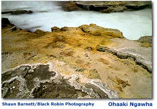
The Ohaaki Ngawha (boiling pool) is the dominant remaining natural feature of the field. Before the area was developed, the large Ohaaki Ngawha with its clear, pale, turquoise-blue water and extensive white sinter terrace was described by Edward Vaile, in his 1939 autobiography Pioneering the pumice, as "the most handsome pool in the whole thermal area".
Condition
Ohaaki is classified as a Development Geothermal System by Waikato Regional Council. The natural features at Ohaaki have been irreparably damaged by development for power generation.
When development commenced, the extraction of geothermal fluid made the water level in the Ohaaki Ngawha drop. This caused the partial collapse of the delicate sinter edge and the white silica formations weathered to a dull dirty grey. The sinter terrace is now cracking and has plants growing through it.
The Ngawha is now fed by geothermal bore water, which contains chemicals added to prevent silica depositing in the bore pipes.
Most of the other flowing surface features at Ohaaki have dried up because of the extraction of geothermal fluid. Before development Ohaaki had:
- several mud pools heated by steam
- hot pools isolated from ground water by a layer of mineralised earth, also heated by steam
- hot springs producing chloride water and depositing sinter.
Very few of these features now remain as anything other than dry hot ground. Most of the springs and pools have dried up and the mud pools have cooled.
The area of steaming ground has expanded, and now an urupā has steam rising through the graves, and the ground has opened up in places.
The only features still containing hot water are those near the Ohaaki Thermal Kilns, which uses geothermal heat obtained from Contact Energy to dry timber commercially to make firewood and has a resource consent to discharge geothermal water to large shallow natural geothermal pools.
Subsidence caused by geothermal development has caused a road to become covered by the Waikato River, and the Ohaaki marae is similarly threatened.
When the power station opened in 1988, it produced 108 megawatts of electricity. Because of cooling of the resource as a result of development, it now produces only 45 megawatts. It is operated by Contact Energy Ltd.
-
About this geothermal system
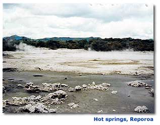
Two springs are still depositing sinter at the Reporoa Geothermal System. Land drainage for farming has lowered the water table, stopping other springs from regenerating sinter deposits.
Natural features
- Hot springs and pools, steaming ground, sinter deposits, mud pools and seepages.
- There are large numbers of the rare fern Christella sp. 'thermal' at Golden Springs.
This field may be connected to the Waiotapu field.
Condition
Reporoa is classified as a Research Geothermal System by Waikato Regional Council. Land drainage for pasture is ongoing. In one area, the drainage has lowered the water table and springs are unable to reach and regenerate sinter deposits.
The outflows of two springs are still depositing sinter. One has its outflow diverted to a channel, so the sinter apron around the spring is not being regenerated.
- Hot springs and pools, steaming ground, sinter deposits, mud pools and seepages.
-
About this geothermal system
Although some natural features remain, sulphur mining has damaged extensive areas of altered ground on the Rotokawa Geothermal System, which have since been rehabilitated. Rotokawa’s acid lake is home to a unique leech.
Natural features
- Sulphur mining between 1960 – 1980s has modified many natural features.
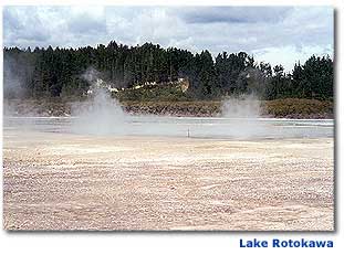
- Lake Rotokawa is Aotearoa's largest geothermal lake.
- An acid lake, sulphur deposits, sinter deposits, mud pools, steaming ground and hot springs remain.
- The lake is home to a unique leech which lives in very acidic water (pH 2.2).
- Springs along the Waikato River are affected by river level fluctuations for hydro-electric generation.
Condition
Rotokawa is classified as a Development Geothermal System by Waikato Regional Council.
The sulphur mining has damaged Rotokawa’s natural features. The mining operation stripped large areas of hot ground, destroying natural contours and geothermal vegetation in the vicinity. The geothermal vegetation is now regenerating on the hot ground.
The Māori land owners and the Department of Conservation are caring for the natural vegetation around the geothermal lake, the geothermal Parariki Stream, and the hot springs by the Waikato River.
A joint venture by the Māori landowners and Mercury Energy produces 35 megawatts of geothermal electricity from a power station built in 1998 and expanded in 2001. In 2010 the Nga Awa Purua geothermal powerstation commenced generating 140 MW of electrical power.
-
About this geothermal field
Rare plants and some natural features remain at Tauhara Geothermal Field, but natural features have been irreparably damaged by development.
Natural features
- Part of the Wairakei – Tauhara system.
- Natural geyser activity has been irreparably damaged.
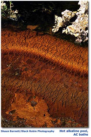
- Hot springs, steam vents, steaming ground, craters, fumaroles, mud pools, sinter deposits and hot seepages still exist.
- The rare thermal ferns Nephrolepsis sp. 'thermal', Christella sp. 'thermal' and Cyclosorus interruptus are present.
- The Spa Sights' geysers were affected by changes in the river's level when the Taupō control gates were installed.
Condition
Tauhara is classified for development by Waikato Regional Council.
Some features are irreparably damaged. Urban development including the rerouting of State Highway 1 through two geothermal areas, an industrial subdivision on Crown Rd, and use of the Crown Rd geothermal area by a motocross club have damaged geothermal vegetation.
Wells at Tauhara also supply the Taupō Hot Springs public swimming pools (previously De Bretts), and the AC Baths, 12 accommodation facilities and numerous domestic bores. Only one sinter depositing spring remains at Tauhara, the Waipahihi Source Spring. There are several locations on the shores of Lake Taupō and the Waikato River where people can bathe in natural hot springs.
Contact Energy runs the two geothermal power stations at Tauhara, being Te Huka and Tauhara. Together they produce 260 megawatts of electricity and supplies geothermal fluid to the Tenon board mill and Nature's Flame wood pellet plant for process heat.
-
About this geothermal system
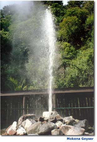
Te Aroha Hot Springs had no significant natural features and has been partly developed to supply hot water to a popular commercial pool complex. The development has created the Mokena Geyser. Te Aroha was one of Aotearoa's first tourism spa complexes.
Natural features
Te Aroha has around ten bicarbonate hot springs, including the Mokena Geyser, a rare bicarbonate geyser well.
The Mokena Geyser is actually an artificially made drill hole that periodically erupts. The outflow is diverted to the spa complex and mixed with cold water for people to soak in. The splash zone around the Geyser has grown a thin coating of white calcite sinter for approximately 1m around the drill hole opening. A small public swimming complex is heated by geothermal water via a heat exchanger. There are other natural springs available for soaking in.
There are no natural sinter deposits and no known significant ecological features at Te Aroha.
Condition
Te Aroha Hot Springs are classified as a Small Geothermal System by Waikato Regional Council.
Originally, there were more than 20 hot springs within the Te Aroha Hot Springs Recreation Reserve, but the number of hot springs has halved. The remaining springs have been developed or modified. Some other warm springs can be found outside the Te Aroha Domain, including at the Te Aroha Holiday Park, which has a thermally-heated swimming pool.
-
About this geothermal system
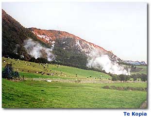
Te Kopia Geothermal System has rare plants and other natural features, including a geyser that has built up a spectacular mud cone.
Natural features
Te Kopia has steaming cliffs and ground, craters, a geyser, a mud geyser, hot springs, sinter deposits and fumaroles. Many of the features are found in a Department of Conservation reserve.
The Te Kopia Mud Geyser erupts a column of grey muddy water 5 to 10 m high as a single shot accompanied by a loud bang. These eruptions occur every 10 to 30 minutes when the geyser is active.
The geyser plasters surrounding vegetation in a thick layer of pale grey mud. It was active from September to December 2000 and manuka and kanuka shrubs within a 20 m radius were bent over under the weight of their mud coating.
Prostrate kanuka, large colonies of the rare ferns Dicranopteris linearis and Christella sp. 'thermal' and the rare bearded orchid Calochilus robertsonii are present.
The vegetation is considered internationally significant because it is the most intact remaining example of natural vegetation extending nearly 600m up the scarp, and is surrounded by mature native Kamahi forest.
Possibly connected to Orakeikorako geothermal system.
History
The Austrian geologist Hochstetter visited and described a geyser similar to the Te Kopia Mud Geyser in the early 1860s. He described its position at the bottom of the steep hillside and its size and activity. It is not thought that the currently active mud geyser is the same feature.
Condition
Te Kopia is classified as a Protected Geothermal System by Waikato Regional Council.
Stock grazing and future logging activities could crush sinter deposits. Possums, pigs and goats have damaged the native vegetation in the reserve, but these are now being controlled by the Department of Conservation.
-
About this geothermal system
This geothermal system has been damaged by poorly planned development, but several geysers, sinter deposits and other natural features remain.
Natural features
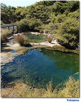
This system has several geysers, sinter deposits, hot springs and pools, steaming cliffs, fumaroles, steam vents and seepages.
The Taumatapuhipuhi Geyser boils to around 1m high for 30 seconds, every two to three minutes. It used to erupt to a height of several metres, but these larger eruptions are now infrequent.
Condition
Natural features have been damaged by poorly planned town development and the building of a tourist path through the features.
A government exploration bore was drilled in 1942. It has been left open and discharging geothermal fluid ever since. This bore loses geothermal fluid at a rate equal to the sum of all other takes.
There are small takes for bathing and heating for a hotel, motels, and domestic use.
Some neighbouring swampy land has been drained and one geyser, Matewai - Hoani Springs, is now usually inactive.
Many of the hot pools and fumaroles at Tokaanu and Waihi are used frequently by the local Maori people for bathing, cooking, and medical and ceremonial uses.
The Hipaua steaming cliffs have caused several fatal landslides and represent an ongoing hazard to State Highway 41 and the Waihi settlement. Find out more about the landslide hazard.
Large-scale energy extraction has the potential to exacerbate this risk, damage or destroy the features, cause heating of ground and hydrothermal eruptions in populated areas, and result in ground subsidence, causing the settlements of Tokaanu and Waihi to become flooded by Lake Taupō.
Accordingly Tokaanu - Waihi - Hipaua has been classified by Waikato Regional Council for limited development.

