Why we monitor peat subsidence
Waikato Regional Council monitors peat subsidence to get an overview of the rate at which drained peat soils are subsiding in the Waikato region. We can see if subsidence is changing over time due to land management practices or natural processes. Monitoring a range of peat areas also helps understand the spatial variability of peat loss.
Peat is almost entirely made up of organic matter. Drainage of peat results in on-going land subsidence and carbon loss.
Subsidence is the gradual lowering of the land surface due to the drained peat shrinking, consolidating and becoming denser. As time passes the slower process of oxidation (microbial breakdown of the organic material) produces carbon dioxide (CO2), a greenhouse gas, and therefore carbon originally stored as peat is lost to the atmosphere.
Other processes that can contribute to peat subsidence include fire, compaction due to stock treading and machinery, wind and water erosion.
Peat subsidence generally decreases over time, but will continue as long as the soils remain drained, until the drained peat disappears.
Drained peat soils, although altered from their original state, are important economically. For example, about 60 per cent of peat soils are used for dairy farming. This represents approximately 10 per cent of the region’s dairy farming land use.
The negative effects of subsidence include the loss of ecosystem services, a need to upgrade flood protection and drainage assets, damage to infrastructure, and impacts on farm productivity. There is limited understanding on the eventual environmental and economic impacts of complete peat loss.
In some areas, the effects of peat shrinkage will be compounded by sea level rise, especially where the underlying sediments are near or below sea level. The level of the Waikato River relative to some areas of peat also causes issues as subsidence progresses.
The subsidence of drained peat soils may impact on the sustainability of adjoining wetland ecosystems.
Oxidation of peat results in the loss of the greenhouse gas, carbon dioxide (CO2) to the atmosphere. Drained peat is also a source of the greenhouse gas, nitrous oxide (N2O).
Peat subsidence may impact on soil processes and have an effect on nutrient cycling and loss, therefore impacting on freshwater quality.
As the regional coverage of this indicator improves (and we build a better understanding of how peat subsidence changes with time, land use, and peat type) we can use the information to help understand the likely impacts of peat loss in the future and plan for these impacts or develop strategies to reduce them.
What's happening?
The Waikato region has about 94,000 ha of peat soils. The mean depth of peat is about 4 m, but this can range from less than 1 m to as much as 12 m.
Originally, these soils represented large areas of unique wetland ecosystems. However, from the late 19th century to the mid-20th century, about 80 per cent of the original area of these wetlands were drained for agriculture, horticulture, and peat mining (for horticultural products).
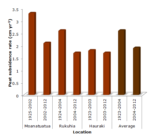
During the most recent measurement period (early 2000s to 2012) the annual rates of subsidence at Rukuhia, Moanatuatua, and Hauraki were approximately 1.7, 2.1 and 1.7 cm per year.
The current average subsidence rate was about 1.9 cm per year. These three areas represent about 30 per cent of our region's peat area.
At Moanatuatua and Rukuhia, annual subsidence rates have decreased between the earlier (1920s to early 2000s) and later time periods.
The higher rates of subsidence during the earlier time period (1920s to early 2000s) at Moanatuatua and Rukuhia compared to Hauraki is probably due to drainage intensification being more recent at Rukuhia (1940s) and Moanatuatua (1950s) than at Hauraki (early 1900s).
If subsidence continues at the current rate, about 1 m of peat will be lost every 50 years.
Water table depth has the single greatest impact on subsidence rate. Therefore, subsidence is most pronounced close to drains and deeper drains have been associated with greater subsidence.
Preliminary data suggests that peat subsidence does not proceed at a constant rate and is linked to time since initial drainage.
Drain deepening to keep ahead of peat loss continuously draws down the water table, resulting in further subsidence and a requirement for even deeper drainage. This cycle results in continued subsidence and, if allowed, this process will continue until all the peat is lost.
Net carbon loss of 2.9 t C ha-1 yr-1 has been reported from one study on a Waikato pastoral agricultural peat soil.
Under the current situation, peat subsidence and carbon loss will continue until all the drained peat has gone. This would result in the loss of a valuable and unique resource.
In the long term we would like to see the regional rate of peat subsidence significantly slow or stop. This will require changes to the way we manage drained peat soils.
Results - data and trends
Peat subsidence due to drainage in the Waikato

The Excel spreadsheet below contains the source data for this indicator's graph and information.
The data were collected in the 1920s, early 2000s, and 2012.
How we monitor
More information
When this indicator is updated
The intention is to eventually update the indicator every 5 years. However, current sampling methods mean this is not possible, and at the moment updates are every 8 to 10 years. New methods are being investigated to reduce the time period between measurements.
Last updated June 2016


