Flood Room status
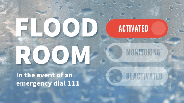
Flood Room is activated. For information on current river levels, flows and rainfall accumulations, please visit our Environmental Data Hub.
What the status levels mean
Flood room is activated: Cyclone Vaianu
Published at 2.50pm on Saturday, 11 April 2026
Situation
Cyclone Vaianu is expected to move south across the North Island, significantly impacting our region from the early hours of Sunday, 12 April. The impact of this cyclone must not be underestimated. Flood Room is activated in response to the event.
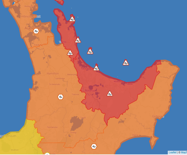
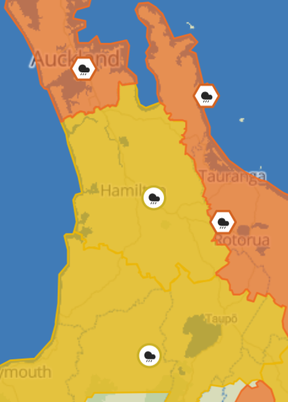
A Strong Wind Warning (Red) and Heavy Rain Warning (Orange) has been issued by MetService for the Coromandel Peninsula. A Heavy Rain Warning is also in place for the Bay of Plenty west of Whakatane including Rotorua, part of which falls within our region.
For the rest of our region - including Waikato, Waitomo, Taupō and Taumarunui - a Strong Wind Warning (Orange) and Heavy Rain Watches have been issued. There is the potential for the 'Kaimai Buster', depending on wind strength and direction.
Meanwhile, a significant wave event, associated with Vaianu, is likely to make beaches hazardous along the eastern Coromandel Peninsula and cause moderate to significant erosion over Saturday and Sunday. Waves may rapidly surge up and down the beach face periodically. The weather system will likely cause minor to moderate coastal inundation impacts, although high coastal water levels may exacerbate river flooding within coastal areas.
The combination of damaging winds, heavy rain and coastal inundation makes this a multi-hazard, potentially life-threatening event. The most severe impacts – such as power outages, falling trees, flooding, slips, road closures and isolated communities – are highly dependent on the cyclone's track.
You are urged to keep up to date with the latest forecasts, adjust plans as needed and be prepared to act, following all advice of civil defence and emergency response agencies.
This forecast adverse weather may cause flooding to some catchments within our region and in particular exacerbate existing landslip risk.
Landslides can occur without any warning signs, even when the rain subsides. If you or people you know are in these areas, please be vigilant to signs of landslides and do not hesitate to act.
Warning signs:
- Small slips, rock falls, and sinking land, at the bottom of slopes.
- Sticking doors and window frames, which may mean the land is slowly moving under the house.
- Gaps where window frames are not fitting properly.
- Steps, decks, and verandas, moving or tilting away from the rest of the house.
- New cracks or bulges on the ground, road, footpath, retaining walls and other hard surfaces.
- Tilting trees, retaining walls, or fences.
- Water flowing out of a slope, like a new spring.
If you learn or suspect that a landslide is occurring, or is about to occur in your area, here’s what to do:
- Move quickly out of its path and stay away from it. Evacuate immediately if it is safe to do so. Your best protection is higher ground outside the path of the landslide.
- If you cannot leave safely, the side of your house furthest from the landslide is likely to be the safest location on your property.
- Take your pets with you and move livestock to safe paddocks if you can do so without endangering yourself.
- Alert your neighbours. They may not be aware of the potential hazard. It may save their lives. Help neighbours who need assistance to evacuate if you can do so without putting yourself in danger.
Be prepared
There are simple preparedness steps you can take now:
- Download the MetService App to your phone to receive weather alerts for your area.
- Add links to your local council and civil defence emergency management websites and follow their social media profiles.
- Check drains and gutters around your property to ensure water can flow freely.
- Secure outdoor items that could blow away or block drainage channels.
- Review your household emergency plan, including how you will stay informed if conditions change.
If an event does occur:
- Avoid driving through floodwaters and plan alternative routes if you live in a flood‑prone area.
- Contact local civil defence (or your council) if you observe any evidence of a landslip or flood impacts.
- Contact 111 if you are in immediate danger.
Please keep up to date with the current MetService weather forecasts and messages from local Civil Defence.
Visit our Environmental Data Hub for the latest river level and rainfall accumulations.
MetService forecast
Changes to the weather can occur quickly, so please keep up to date with the latest forecasts. For national severe weather information, MetService is New Zealand’s only authorised provider of Severe Weather Alerts. Download the MetService App to your phone to receive weather alerts and access rain radar information for your area.
Wind
Strong Wind Warning (Red) – Coromandel Peninsula and Great Barrier Island
Period: 20 hours from 10pm Saturday to 6pm Sunday
Forecast: Severe gale easterlies changing to severe gale west to northwesterlies Sunday afternoon, with damaging gusts of 130km/h in exposed places. Note winds easing from the north during Sunday afternoon.
Impact: Threat to life from flying items and falling trees. Destructive winds will cause widespread damage including powerlines and roofs, with dangerous driving conditions and significant disruption to transport and power supply.
Action: Stay indoors or seek sturdy shelter away from trees. Avoid travel. Be ready for power and communication outages.
Strong Wind Warning (Red) – Bay of Plenty and Rotorua
Period: 16 hours from 4am Sunday to 8pm Sunday
Forecast: Severe gale easterlies changing to severe gale northwesterlies Sunday afternoon, with damaging gusts of 130km/h in exposed places.
Impact: Threat to life from flying items and falling trees. Destructive winds will cause widespread damage including powerlines and roofs, with dangerous driving conditions and significant disruption to transport and power supply.
Action: Stay indoors or seek sturdy shelter away from trees. Avoid travel. Be ready for power and communication outages.
Strong Wind Warning (Orange) – Waikato, Waitomo, Taupō and Taumarunui
Period: 20 hours from 2am Sunday to 10pm Sunday
Forecast: Severe gale easterlies changing to severe gale westerly late afternoon or evening Sunday, gusting 120km/h in exposed places.
Low chance of upgrading to a Red Warning.
Impact: Damage to trees, powerlines, and unsecured structures possible. Driving may be difficult, especially for high-sided vehicles and motorcycles.
Action: Prepare your property by securing items that can be picked up by strong winds. Drive cautiously.
Rain
Heavy Rain Warning (Orange) – Coromandel Peninsula, and Bay of Plenty west of Whakatane including Rotorua
Period: 17 hours from 11pm Saturday to 4pm Sunday
Forecast: Expect 120 to 150 mm to accumulate, especially about the ranges. Peak intensities of 25 to 40 mm/hr possible in localised downpours Sunday morning and afternoon. Note, in addition to the wind and rain, large swells and coastal inundation are likely. Low chance of upgrading to a Red Warning.
Impact: Streams and rivers may rise rapidly. Surface flooding, slips, and difficult driving conditions possible.
Action: Clear your drains and gutters to prepare for heavy rain. Avoid low-lying areas and drive cautiously.
Heavy Rain Watch (Yellow) – Waikato
Period: 17 hours from 1am Sunday to 6pm Sunday
Forecast: Periods of heavy rain, and amounts may approach warning criteria. Moderate chance of upgrading to a Warning.
Heavy Rain Watch (Yellow) – Waitomo, Taumarunui, Taupō and Taranaki
Period: 12 hours from 8am Sunday to 8pm Sunday.
Forecast: Periods of heavy rain, and amounts may approach warning criteria. Moderate chance of upgrading to a Warning.
Thunderstorms
There are no Thunderstorm Watches or Warnings. However, there is a possibility severe thunderstorm watches or warnings may be issued by MetService at short notice, so please be alert for and act on these without hesitation – do NOT wait for further analysis by Waikato Regional Council.
For information on preparing for and keeping safe during a storm, see the National Emergency Management Agency's Get Ready website.
Likely/potential Impacts
Rivers and lakes
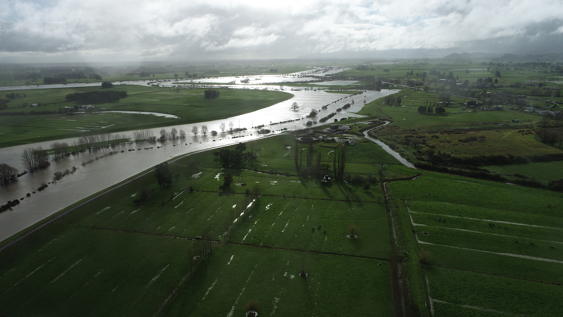
Rivers and streams are likely to rise, and flooding may occur in low-lying areas. Avoid driving through floodwaters and plan alternative routes if you live in a flood‑prone area.
Wind
Strong Wind Warnings are in place for the Waikato region, with a red-level warning for the Coromandel Peninsula. There is the potential for the 'Kaimai Buster', depending on wind strength and direction. Read more about the Kaimai Buster.
Trees may fall and powerlines may come down (treat all as live). Any unsecured items may be uplifted, so now is a good time to tie them down or bring them inside. High-sided vehicles may be affected by strong winds.
Please keep up to date with information from your local power provider, the NZ Transport Agency Waka Kotahi and local civil defence.
Coastal impacts
A significant wave event, associated with Vaianu, is likely to make beaches hazardous along the eastern Coromandel Peninsula and cause moderate to significant erosion. For coastal inundation, the weather system will likely cause minor to moderate impacts. Please note the information below is based on current coastal forecasts and may change between now and Saturday.
Eastern Coromandel
A significant wave event is expected for eastern Coromandel beaches during Saturday and Sunday, making beaches hazardous, particularly over high tides.
The significant wave event will likely cause waves to reach the lower dunes. Intermittently, there may be some wave run up that overtops low lying dune areas and coastal infrastructure. Waves may rapidly surge up and down the beach face periodically, therefore caution is necessary on the beaches during Saturday and Sunday.
The significant wave event is likely to cause moderate erosion impacts along many eastern Coromandel beaches. Significant erosion will very likely occur at Whangapoua, Matarangi, Kūaotunu, Hot Water Beach, Onemana, Whangamatā, Pauanui and Buffalo Beach, Whitianga.
For Buffalo Beach and Brophy’s Beach, there is likely to be some wave overtopping onto SH25 in low lying sections during 2 hours either side of high tide (and possibly longer) on Sunday and Monday morning.
For eastern Coromandel towns, coastal inundation will likely be minor to moderate, although high coastal water levels may exacerbate river flooding within coastal areas.
Firth of Thames
For Firth of Thames, along the Thames Coast and Wharekawa Coast, there may be some wave splashing along low lying areas, approximately 2 hours before and after high tides, on Sunday and Monday morning. From Monday onwards, there may be some wave splashing along the Thames Coast.
West Coast
For the west coast of the Waikato region, coastal impacts are unlikely to be significant.
High tide times
The coastal impacts are expected during high tides on Saturday, Sunday and Monday. The highest tides will likely occur over Sunday afternoon and early Monday morning.
The high tides for Whitianga are:
Saturday 11/04/2026
High tide - 01:20 am
High tide - 01:32 pm
Sunday 12/04/2026
High tide - 02:13 am
High tide - 02:27 pm
Monday 13/04/2026
High tide - 03:07 am
High tide - 03:24 pm
The high tides for Firth of Thames are:
Saturday 11/04/2026
High tide - 01:22 am
High tide - 01:34 pm
Sunday 12/04/2026
High tide - 02:19 am
High tide - 02:28 pm
Monday 13/04/2026
High tide - 03:17 am
High tide - 03:27 pm
Land instability
Areas that would normally experience land instability may be affected.
Any localised downpours that develop about the hill country and ranges of the region will heighten the risk and people in these areas should remain vigilant for early warning signs of earth movement. Road users should plan ahead and keep up to date with the latest from their local council and the NZ Transport Agency Waka Kotahi.
Contact local civil defence (or your council) if you observe any evidence of a landslip or flood impacts. Dial 111 if you are in immediate danger. Road users should plan ahead and keep up to date with the latest from their local council and the NZ Transport Agency Waka Kotahi.
What we're doing
Our Regional Flood Response team of scientists and subject matter experts is analysing the latest data and providing advice to other agencies around the region. This includes a range of functions such as severe weather analysis, understanding and responding to the flood impacts in the region, and ensuring our flood defence systems are operating at full capacity. This data is received, analysed and disseminated 24 hours a day.
The team has integrated with the regional civil defence emergency management (CDEM) team, ensuring the right staff are in place for Waikato Regional Council's response over the weekend. We also continue to liaise closely with civil defence, local councils and other agencies, providing severe weather impact analysis and support to local flood response operations.
Waikato Regional Council flood and drainage schemes
Our managed flood infrastructure has withstood the challenges of the recent weather. All flood defence systems have been inspected over the last 48 hours to ensure functionality. Our local operations staff will remain on standby to monitor flood and drainage schemes and will respond as necessary to any issues.
Waikato Regional Council telemetry
Our telemetry network continues to provide real-time data on rainfall and river levels and is monitored 24/7 by our Regional Flood Response team. Visit our Environmental Data Hub for the latest river level and rainfall accumulations.
Next update
Flood Room will be updated by 1pm on Sunday, 12 April, or earlier if the situation changes.
New Zealand Flood Pics
New Zealand Flood Pics is a photographic archive of flooding for Aotearoa New Zealand which is currently hosted by the National Institute of Water and Atmospheric Research (NIWA). It's free for anybody to upload or download flood photographs and your contributions are welcomed.