



The Waikato Integrated Scenario Explorer (WISE) is a dynamic, spatially explicit modelling tool that assesses the impacts and trade-offs of future development scenarios and policy options.
It integrates economic, demographic, environmental and land-use data to support evidence-based planning and decision-making across the Waikato region.
The full use of WISE is currently under review as central government's proposed local government reforms progress and more detail becomes available on regional scenario planning under the new planning system. In the meantime, the latest 2023 WISE projections for land use, population, households, employment and economic activity are available on this website.
 What is WISE?
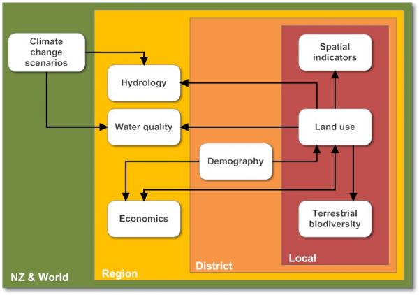
WISE Version 1.4 integrates a set of linked models that operate across four spatial scales:
- New Zealand and the world
- the Waikato region
- cities and districts
- local-scale land use change and terrestrial biodiversity assessments.
There are more detailed sub-models, each of which varies in detail, data, and internal structure.
The diagram shows the system design. Arrows represent links or flows among the different models. The direction of the arrow shows the direction of flow.
WISE operates on an annual time step, with simulations beginning in 2018 and ending in 2067.
 The development of WISE consisted of a four stage process:
Key assumptions in Reference Scenario
The Reference Scenario is set up in WISE Version 1.7 to represent the modelled projections of population and economic growth for the region and the current policies and plans that influence growth and land use development.
Establishing this Reference set up required a number of assumptions to be made. An overview of the key assumptions made in the Reference Scenario and results are reported in the documents below.

